Drones may not have a very good reputation but they’re trying to clean up their image. As Amazon considers drone delivery, and Facebook initiates plans to provide internet connection in remote areas via drones, can humanitarians benefit from them too?
As humanitarians, we are often confronted with challenging problems that must be solved rapidly with limited resources. Thanks to new and emerging technologies coming to the rescue, the potential to save time and resources is at our fingertips. Studies have pointed to the use of unmanned aerial vehicles (UAVs) or “drones” as having the ability to provide higher resolution and more targeted imagery of affected areas. The use of UAV-sourced imagery may be a solution to unlocking the potential power of crowdsourced damage assessments. These technologies hold huge potential.
However, there’s still some uncharted territory here: the ethical and privacy issues involved, as Maya Kapsokavadis explains in her recent blog post (link missing). How do we know if these technologies will actually work in an urban humanitarian response setting? Can they provide us with more timely and accurate information than the tools that we currently have?
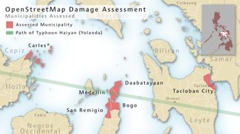
In order to begin to answer some of these questions, the REACH Initiative embarked on a research project during the Typhoon Haiyan response in the Philippines. The purpose of the research – done together with the American Red Cross, Humanitarian OpenStreetMap Team (HOT OSM), Global Shelter Cluster and the U.S. Office of Foreign Disaster Assistance (OFDA) – was to understand how the accuracy of traditional field-level damage assessment compared to remote damage assessments which use technology such as satellite imagery and crowd-sourcing.
Responding to Typhoon Haiyan brought unique challenges. With an estimated total of 1,910,547 individuals displaced by the Typhoon and a reported 1,127,041 damaged houses – 548,793 of which were totally destroyed – the traditional means of ground damage assessments seemed like a nearly impossible task to complete.
Although more research needs to be done to test the accuracy, utility and relative resource needs for UAV-sourced imagery, the potential power of this in tandem with crowdsourcing platforms, such as OSM, is exciting.

The future of damage assessments could sit on the computer screens of tens of thousands of crowdsourced contributors using a single UAV image rather than in the hands of a handful of ground assessors spending long, hot days collecting data in the field. REACH hopes to conduct similar research on a larger scale with the added variable of UAV-sourced imagery in a future humanitarian response.
For more information, visit: www.reach-initiative.org and www.reachresourcecentre.info. You can contact the REACH Coordinator, Vincent Annoni, at vincent.annoni@impact-initiatives.org.
Questions for Discussion:
- What are the potential ethical and security implications of using imagery derived by UAVs for remote damage assessments in humanitarian contexts?
- What are the strengths and weaknesses of using crowdsourcing platforms to conduct tasks as critical to a humanitarian response as a damage assessment given that they do not currently sit within the humanitarian coordination infrastructure?
- What other technologies might be used – or tested – in similar research to understand the benefits and limitations of these for humanitarians?
- How can humanitarians reach out to other sectors/communities to jointly deploy these technologies in an appropriate manner?